Wildflowers of South Mill St., Hopkinton, Mass.
The South Mill Street Environment
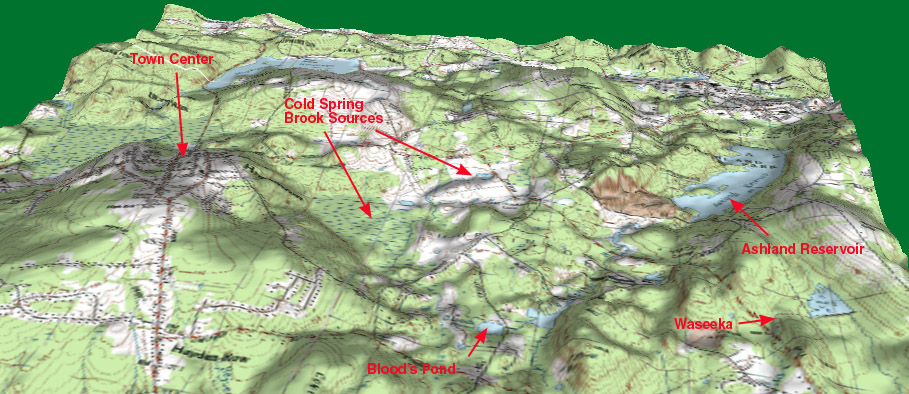
Hopkinton is a town of 13,000, about 25 miles west of Boston. It lies in the extreme southwest corner of Middlesex County, and at 26.6 square miles it ties with Westford as the largest area town in the county. At 500 people per square mile it is fairly sparsely populated, even though it is considered more than 50% built out based on current zoning laws. One reason for this sparseness is the large areas occupied by lakes (4 large ones), extensive wetlands, two state parks and the 900-acre Weston Nurseries (half of which is now up for sale).
South Mill Street is a fairly long street, but split geographically into two sections by a main road that crosses it. We live on the mile-long northern half that is described here.
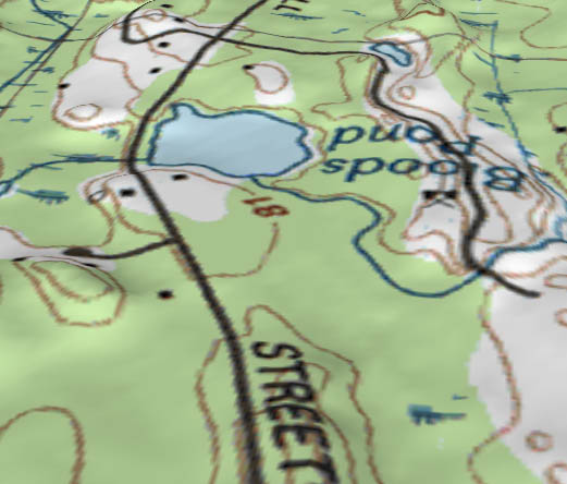
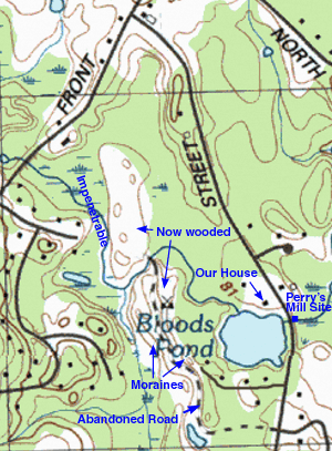
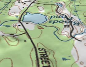
While the center of Hopkinton at an elevation of 534' may be the highest town center in the county, our house at 261' is one of the lowest spots in town. Only a few houses downstream of us are a few feet lower. We are immediately adjacent to Bloods Pond, a shallow 6.5-acre pond created before 1800, when an earthen dam was built across Cold Spring Brook to provide power to Perry’s Mill, a saw and grist mill. Until about 1989, this house was the only property on the pond, but since then the owner subdivided the land there are 4 new houses on the far side of the pond. Thankfully, that is the end of development possibilities anywhere near the pond, as a significant wetland area borders the rest of it. The remainder of South Mill St. north of the pond has about 10 houses on it, with space for another 6 or 7 possible in future years.
 Behind our house and along most of South Mill St. are mixed woods, and the entire area is over 90% forested. Most of the trees are pine, oak, hemlock, maple and ash, but there are also beech, chestnut (small ones, of course), hornbeam, spruce, willow and one very large cottonwood with a trunk 4 feet in diameter. A few birch, poplar and crabapple trees grow along the pond and stream, and there are many woody flowering shrubs listed in these wildflower pages.
As with much of New England, the area was farmed or logged once, so only a handful of trees are over 100 years old, and many have been logged in as recently as 1991. There are a number of old stone walls in the area, some barely discernable in the woods, and South Mill Street itself is designated a Massachusetts Scenic Road in order to preserve the stone walls and trees.
Behind our house and along most of South Mill St. are mixed woods, and the entire area is over 90% forested. Most of the trees are pine, oak, hemlock, maple and ash, but there are also beech, chestnut (small ones, of course), hornbeam, spruce, willow and one very large cottonwood with a trunk 4 feet in diameter. A few birch, poplar and crabapple trees grow along the pond and stream, and there are many woody flowering shrubs listed in these wildflower pages.
As with much of New England, the area was farmed or logged once, so only a handful of trees are over 100 years old, and many have been logged in as recently as 1991. There are a number of old stone walls in the area, some barely discernable in the woods, and South Mill Street itself is designated a Massachusetts Scenic Road in order to preserve the stone walls and trees.
Cold Spring Brook, which runs through our property into the pond, appears to have been partially enlarged 200 years ago to better feed the pond, and some of its banks have been built up with stones. The shore of the pond next to our house also appears built up, as it is an extremly steep 5-foot drop to the water, though it is entirely overgrown now. The brook is about 30' wide where it enters the pond narrowing to about 10' about 1/2 mile upstream where it mostly disappears into a swamp. All of the area on both sides of the stream for about a mile upstream is wetlands, or close enough to wetlands that development is impossible. However there are enough ribbons of high ground along both sides of the stream to allow for a narrow foot trail, passable except at times of highest water.
We refer to the woods behind our house as the “Outback”, while the swamp encircling it has no special name. Running north-south right down the center of the main swamp are a series of small glacial hills (drumlins or moraines?) that were extensively excavated over the years for their gravel. The last gravel pit probably ceased operation before the 1960's (the topographic map at right indicates a gravel pit symbol). Today it is thoroughly forested and overgrown so you would not know it was once quarried, except for the strange, narrow linear ridges, about 20-30' high with very steep sides, between very flat, smooth trails. The ridges are actually the side walls of the moraines that were left alone because the better gravel was in the center, and the flat trails are probably former roads for dump trucks. The hills make for interesting topography in what would otherwise be perfectly level wetlands.
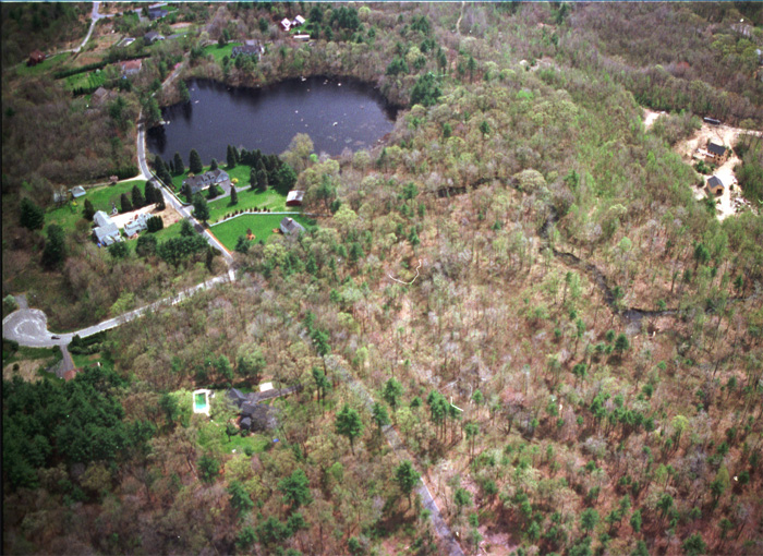
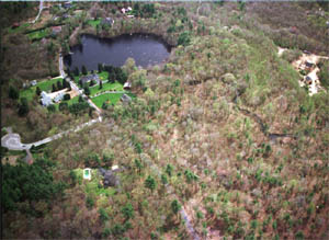
| The pictures below are looking south (opposite the map above) from a height of about 1000'. |
 |  |
The combination of pond, stream, wetlands, hills and former disturbed areas makes for a rich environment for wildflowers. It became quickly clear to me after starting this project that the greatest variety of wildflowers is found at the edges of clearings. A clearing could be the yard, road, pond, swamp or some disturbed area. In the deeper woods, flowers are relatively rare. In most of New England one sure way to get a lot of wildflowers is to let an area of your lawn go to seed for a few years, keeping only the large woody shrubs and trees in check. Each year the pattern of natural evolution will yield different plants, but as time goes on it becomes less diverse. For a while it may seem stabilized, with most of the area taken over by a few species of shrubs (a major part of which, unfortunately, is the invasive
) or tall wildflowers like goldenrods. But then a few years later, small pine tree saplings that you never noticed before start to get taller than the flowers and shrubs, at which time it looks more like a forest, where wildflowers and small plants in general are few and far between.
Cold Spring Brook drains a large enough area that it can rapidly become a torrent at times of high water. While often it is only a few inches deep, or even totally dry late in the summer, in early spring it can get deep enough for a half-mile, exciting tubing trip (with wetsuit, of course). A 4" or 5" rain over a day or two (which we get once or twice a year) can raise the water level 3' in one day and completely flood the wetlands upstream of the pond. The pond gets 3' higher, too, but it has such high banks on all sides it just gets deeper, not wider.
Some of the wildflowers in these pages came from areas outside the immediate area of this above map, marked below. A mile and a half northwest lies Ashland Reservoir in Ashland State Park, fed mainly by Cold Spring Brook, and an equal distance to the east lies
Waseeka Wildlife Refuge, a small Massachusetts Audobon Society sanctuary with a sizeable pond (also created by a dam built long ago). About 5 miles to the west lies Whitehall Lake and Whitehall State Park, the source of some of the aquatic flowers listed here. A handful of flowers came from other areas we often visit, such as Mt. Desert Island on the coast of Maine, the White Mountains of New Hampshire, and the Finger Lakes region of New York. However I have not done any serious wildflower “exploration” in these other regions.